Where precision meets simplicity
Lorem ipsum dolor sit amet, consectetur adipiscing elit. Suspendisse varius enim in eros elementum tristique.


Where precision meets simplicity
Heading
This is a heading sample text
Lorem ipsum dolor sit amet, consectetur adipiscing elit. Suspendisse varius enim in eros elementum tristique.
Heading
Lorem ipsum dolor sit amet, consectetur adipiscing elit. Suspendisse varius enim in eros elementum tristique. Duis cursus, mi quis viverra ornare, eros dolor interdum nulla, ut commodo diam libero vitae erat. Aenean faucibus nibh et justo cursus id rutrum lorem imperdiet. Nunc ut sem vitae risus tristique posuere.
Heading
Lorem ipsum dolor sit amet, consectetur adipiscing elit. Suspendisse varius enim in eros elementum tristique. Duis cursus, mi quis viverra ornare, eros dolor interdum nulla, ut commodo diam libero vitae erat.
Heading
Lorem ipsum dolor sit amet, consectetur adipiscing elit. Suspendisse varius enim in eros elementum tristique. Duis cursus, mi quis viverra ornare, eros dolor interdum nulla, ut commodo diam libero vitae erat.
Heading
Lorem ipsum dolor sit amet, consectetur adipiscing elit. Suspendisse varius enim in eros elementum tristique. Duis cursus, mi quis viverra ornare, eros dolor interdum nulla, ut commodo diam libero vitae erat.
Work done. Faster.
Welcome back! See how ArcSite can transform your business
You’ve explored ArcSite before—now, it’s time to experience the difference firsthand. With ArcSite, you can streamline everything from drawing to takeoffs and estimates.
Still Wondering How ArcSite Fits Into Your Business?
In just 15 minutes, we’ll walk you through the key features and custom solutions that align with your projects and goals.
Your free live demo includes:
- Quick introduction to ArcSite
- Overview of your current process/workflow
- Custom walkthrough of ArcSite specific to your business and industry


REQUEST A Free DEMO
Thanks for requesting a demo!
Your submission was received, we’ll be in touch shortly.
Heading
Lorem ipsum dolor sit amet, consectetur adipiscing elit. Suspendisse varius enim in eros elementum tristique. Duis cursus, mi quis viverra ornare, eros dolor interdum nulla, ut commodo diam libero vitae erat. Aenean faucibus nibh et justo cursus id rutrum lorem imperdiet. Nunc ut sem vitae risus tristique posuere.
Heading
Lorem ipsum dolor sit amet, consectetur adipiscing elit. Suspendisse varius enim in eros elementum tristique. Duis cursus, mi quis viverra ornare, eros dolor interdum nulla, ut commodo diam libero vitae erat. Aenean faucibus nibh et justo cursus id rutrum lorem imperdiet. Nunc ut sem vitae risus tristique posuere.
21+ million drawings, takeoffs, and proposals created with ArcSite!


















Heading
Heading
Lorem ipsum dolor sit amet, consectetur adipiscing elit. Suspendisse varius enim in eros elementum tristique. Duis cursus, mi quis viverra ornare, eros dolor interdum nulla, ut commodo diam libero vitae erat.


Heading

3 Ways to Quote Faster Without Losing Accuracy

How We Built Topographic Drawings
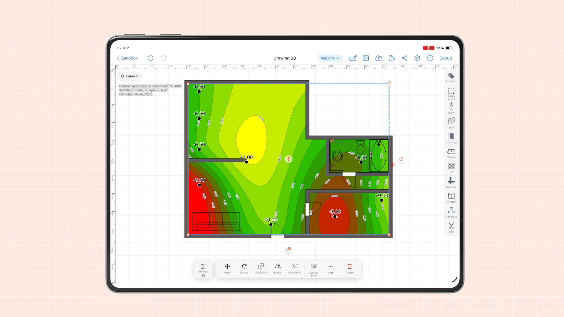
ArcSite Launches Topographic Drawings, Turning Elevation Problems Into Something Customers Can See
Heading
Lorem ipsum dolor sit amet, consectetur adipiscing elit. Suspendisse varius enim in eros elementum tristique. Duis cursus, mi quis viverra ornare, eros dolor interdum nulla, ut commodo diam libero vitae erat.



















.avif)
.avif)
.avif)
.avif)
.avif)
.avif)

.avif)


.avif)

Heading
Lorem ipsum dolor sit amet, consectetur adipiscing elit. Suspendisse varius enim in eros elementum tristique. Duis cursus, mi quis viverra ornare, eros dolor interdum nulla, ut commodo diam libero vitae erat. Aenean faucibus nibh et justo cursus id rutrum lorem imperdiet. Nunc ut sem vitae risus tristique posuere.
Yes. ArcSite links with field service management apps and CRMs like Jobber, Housecall Pro, and Salesforce, along with accounting tools like QuickBooks, to prevent duplicate data entry between the field and the office.
ArcSite connects directly with Bluetooth laser measures like Bosch and Leica, as well as measurement tools like Moasure. Dimensions transfer straight onto the digital canvas, eliminating manual typing and scaling errors.
Yes. ArcSite supports multiple types of site capture, including indoor AR room scans, exterior topographical drawings, and property elevation maps, giving contractors a single platform for all project types.
Because ArcSite is SOC 2 Type II compliant, the vendor assessment process moves forward much faster. The certification provides security and IT teams with clear, third-party validation of corporate governance, control environments, and risk management practices to accelerate procurement and onboarding.
Yes. ArcSite is SOC 2 Type II compliant, providing independently verified assurance that systems, processes, and controls for managing customer data have been rigorously audited. This certification validates the platform's commitment to data protection, operational integrity, and reduced third-party risk.
ArcSite unites field and office workflows through centralized product libraries, role-based access control, and multi-user digital blueprint collaboration. This ensures team members across active projects and regional offices can maintain brand consistency and operational alignment.
A digital tape measure app swaps the physical tool for your phone's camera, so you capture a distance without unrolling anything. AR Site Capture goes a step further: scanning the line doesn't just give you a number, it drops a scaled measurement onto your drawing and lets you place a product on it right there, so the measurement is already part of your estimate instead of a figure you have to enter somewhere else.
More accurate, because it skips the two places a tape measure usually goes wrong: misreading it and mistyping the number afterward. AR Site Capture pulls the measurement straight from the real world and puts it directly on your canvas at scale. What you scan is what lands on the drawing, no reading, no writing it down, no re-entering it later.
Yes. Point your phone's camera at the line and walk it. AR Site Capture scans the distance and drops a perfectly scaled line straight onto your drawing, no tape measure and no second person holding the other end. It works for fence runs, walkways, and trenches: any run you'd normally have to pace off by hand.
Yes — ArcSite adapts to system designs of any size, from single-unit residential jobs to larger commercial layouts.
Yes — ArcSite's HVAC takeoff tools calculate material quantities directly from your on-site drawing, tied to your own price list.
Yes — draw the system layout, generate the takeoff, and send a quote before you leave the property.
Yes — Topographical Drawing tools let you map elevation and drainage before finalizing your design and estimate.
Yes — draw the layout, generate the takeoff, and send a proposal before you leave the property.
Yes — ArcSite's landscape takeoff software calculates material quantities directly from your on-site drawing, tied to your own price list.
Yes — mark up exact device locations, camera coverage, and access points directly on your drawing for clear, professional security plans.
Yes — ArcSite adapts to general security site assessments as well as more specialized physical and protective security design work.
Yes — document findings, mark up your site plan, and generate a report before you leave the property.
Yes — ArcSite adapts to inspections of any building type and size, from single-family homes to larger commercial properties.
Yes — document findings, mark up your site plan, and generate a report before you leave the property.
Yes — ArcSite is available on iOS, Android, and Windows tablets, so you can draw, document, and report during field visits, inspections, and site surveys without going back to the office.
Yes — capture drawings, fill out inspection forms, take photos, and annotate all offline; everything syncs automatically once you're back online.
Yes — document findings, mark up your site plan, and generate a report before you leave the property.
Yes — ArcSite is available on iOS, Android, and Windows tablets, so you can draw, document, and report during field visits, inspections, and site surveys without going back to the office.
ArcSite is built for field fire-protection technicians and inspection companies doing on-site documentation and reporting — not municipal permitting or code-enforcement workflows.
Yes — ArcSite lets you build custom checklists for each system type, tied directly to your site drawing.
Yes — document findings, mark up your site plan, and generate a report before you leave the property.
Yes — ArcSite adapts to roof layouts of any size or complexity, from single-family homes to larger commercial jobs.
Yes — ArcSite's roofing takeoff tools calculate square footage and material quantities directly from your on-site drawing, tied to your own price list.
Yes — draw the roof layout, generate the takeoff, and send a quote before you leave the property.
Yes — ArcSite adapts to any flooring type, from hardwood and tile to carpet and vinyl, with custom material libraries for each.
Yes — draw the layout, generate the takeoff, and send a proposal before you leave the property.
Yes — ArcSite's flooring takeoff tools calculate square footage and material quantities directly from your on-site drawing, tied to your own price list.
Yes — convert your drawing into an instant takeoff with material quantities, ready to attach to your estimate.
Yes — ArcSite includes a library of electrical symbols along with snap-to-grid and scalable elements for accurate, professional diagrams.
Yes — draw the diagram, generate the estimate, and send a quote before you leave the property.
Yes — draw the layout, generate the takeoff, and send a proposal before you leave the property.
Yes — ArcSite's plumbing takeoff tools calculate pipe runs, fixture counts, and material quantities directly from your on-site drawing.
Yes — draw the system layout, generate the takeoff, and send a proposal before you leave the property.
Yes — ArcSite's irrigation takeoff tools calculate material quantities directly from your on-site drawing, tied to your own price list.
Yes — Topographical Drawing tools let you map site elevation and grade before finalizing material quantities and pricing.
Yes — draw the job, generate the estimate, and send a signable proposal before you leave, using ArcSite's concrete estimating software.
Yes — ArcSite's concrete takeoff software calculates volume, rebar length, and formwork directly from your on-site drawing, tied to your material price book.
Two things: the drawing PDF as an attachment on the estimate, and the priced line items from your ArcSite takeoff, including products, markup, discounts, and tax. They land on the same Housecall Pro estimate, so your totals stay in one place.
Yes, as long as their Housecall Pro email matches an active ArcSite user in your company. Matched employees are added to the Project as Collaborators. If an email doesn't match, the Project is still created, just without that person added.
Scheduling an estimate in Housecall Pro. The moment an estimate is scheduled, Housecall Pro tells ArcSite to create a matching Project, usually within a few minutes.
External tools require exporting data, switching apps, and manually recreating visuals, which can take 10-15 minutes per job and produces inconsistent results across reps. ArcSite generates the contour map automatically inside the drawing, with no extra steps.
No. Topographical drawings are built into ArcSite's existing drawing environment. If your team already uses ArcSite, the learning curve is minimal. Standardized settings also mean new reps can produce consistent output quickly.
Yes. Because the topographical drawing lives inside ArcSite, it connects directly to your estimates and proposals. You can present the visual and the quote in the same workflow, on the same visit.
Once you place elevation points on your drawing, ArcSite automatically calculates and generates contour lines and a color-graded heatmap. The whole process happens inside the app with no manual drawing or file exports.
No. You enter elevation points directly into ArcSite using your tablet or phone. No external sensors, survey equipment, or third-party apps required.
It's designed for professionals who need to show elevation changes to clients on-site. Any field team that deals with sloped terrain, ground settlement, or elevation-sensitive pricing can benefit.
Yes. The Moasure 2 Series is designed for real-world estimating and takeoffs, and when paired with ArcSite, it provides a reliable end-to-end workflow from measurement to client-ready proposal.
No. With the integration, measurements transfer directly into ArcSite from within the app. Exporting DXF, DWG, CSV, or PDF is only needed if you are working outside the integrated workflow, or if you’re not on an ArcSite plan that includes software integration.
Absolutely. The integration is optional, so you can use Moasure when you want faster site capture, orcontinue using ArcSite on its own when needed. Both workflows work independently.
Financing helps contractors grow their businesses while staying competitive: Win more jobs by offering affordable monthly payment options. Increase average ticket sizes with larger, accessible project scopes. Improve cash flow with reliable funding in as little as 24 hours. Streamline operations with tools like automated workflows and dashboards for tracking installations. By integrating financing into their sales process, contractors can secure customer trust, increase close rates, and scale their operations efficiently.
Contractors can sign up easily via our online application portal. Sign up here: https://sunlightfinancial.com/arcsite. Provide appropriate documentation, such as contractor licenses, proof of business credentials, and banking details. Sunlight Financial will review your application and guide you through onboarding for a seamless setup process.
Payments are processed as fast as 24 hours after project verification. Payments are tracked in real-time via the Orange® and Tangerine™ portals. A Remittance Dashboard provides daily payment reports and transaction insights, ensuring accuracy in managing project financing.
Sunlight Financial offers loan amounts up to $100,000 and multiple APR and loan term combinations to meet the diverse needs of homeowners. Our comprehensive suite includes options with: Diverse term lengths and repayment structures. Promotional loan offers to support affordability. Tools like the Product Management feature in the Orange® platform for tailored solutions.
Sunlight finances a wide variety of home improvement projects, such as: Roofing, Foundation Repair, Windows & Doors, Kitchen & Bath Renovations, Interior & Exterior Remodeling, Decks & Patios, Fencing, Energy Efficiency Improvements, Home Automation, And More. Eligible property types include: Owner-occupied primary or secondary homes, Single-family residences, Investment properties, Multi-family residences (up to 4 units), Townhomes or row homes. This comprehensive eligibility allows contractors to assist a wider range of homeowners with diverse project needs.
Yes—Sunlight Financial offers highly competitive interest rates. With a wide choice of programs including promotional plans, 0% dealer-fee options, and competitive APRs, contractors can match financing to customer budgets and project needs. Additionally, our Prime Plus Lending and Sunlight Maxx® programs support strong approval rates without sacrificing affordability.
There are no platform fees to join Sunlight Financial. Contractors get free access to the Orange® sales portal, dashboards, reporting tools, and financing workflows. While dealer fees may apply to certain loan products, Sunlight Financial also offers zero-dealer-fee options, giving you flexibility to match loan products to your pricing and margins.
Yes! Unlike standalone scanning apps, ArcSite seamlessly integrates LiDAR scans into material take-offs, estimates, and proposals, streamlining the entire workflow.
Yes! The scanner is designed to work in real-world conditions, meaning you don’t need an empty room. However, excessive clutter or obstacles blocking walls may reduce accuracy.
Yes. It can capture linear based measurement and straight line projects. Perfect for scanning fence lines, concrete slabs, and much more.
Yes! Once a scan is complete, you can adjust room dimensions, add custom details, and modify layouts directly within ArcSite.
Yes, the feature is only available on Apple Pro devices with LiDAR sensors, here’s a list of compatible devices It is not available on standard iPhones, iPads, or Android devices.
Yes—good lighting improves accuracy by allowing the LiDAR sensor to detect surfaces clearly. While the scanner can handle cluttered spaces, large furniture or objects blocking walls may impact results.
For best results, scan one room at a time. If a room exceeds 2,000 sqft, it should be scanned in sections and then merged. Multiple rooms can be scanned separately and combined manually within ArcSite.
The scanner captures area and linear based projects, including walls, doors, and major openings. Additionally, it can capture fence lines or foundation cracks. It does not currently detect ceiling fixtures, or detailed architectural elements.
Scans typically achieve within inches of actual dimensions, making them highly precise for estimating and design. While LiDAR is extremely reliable, minor adjustments may be needed based on lighting and scanning speed.
The feature is ideal for professionals and homeowners who need quick, accurate floor plans without manual measuring. Key users include Contractors & estimators – Faster site measurements for proposals and take-offs, Basement & waterproofing pros – Quickly scan interior layouts for project planning, Foundation & gutter specialists – Capture precise room dimensions without tape measures, Inspectors & builders – Generate digital floor plans instantly for reports and documentation, and Homeowners & DIYers – Easily create accurate room layouts for renovations.
Using the built-in LiDAR sensor on supported Apple devices, the scanner detects walls, doors, and room openings, capturing precise dimensions and converting them into a fully editable ArcSite drawing in seconds.
The ArcSite LiDAR Room Scanner is a feature that allows users to scan an interior space using a LiDAR-equipped iPhone or iPad Pro to instantly generate an accurate, editable 2D floor plan—no manual measuring or drawing required.
You'll benefit from dedicated customer success managers, personalized onboarding, and tailored implementation support to maximize your productivity.
Absolutely! ArcSite offers premium integrations with various software tools, ensuring seamless connectivity. These integrations are available in our Takeoff, Estimate, and Estimate Elite tiers!
If you pay upfront for an annual Takeoff or Estimate subscription, you'll receive one month free, adding up to a $129 value.
The $50 per user promo give you access to ArcSite's Takeoff and Estimate tools. This is up to a 70% discount off our regular priced license for your first month.
ArcSite minimizes errors through automatic proposals and takeoffs, which are generated based on precise site data collected through the app. This ensures accuracy and efficiency in your designs and proposals.
Yes, ArcSite offers customizable features including custom forms for data collection, tailored drawing tools, and adjustable settings to meet the specific needs of your project.
ArcSite is used by professionals across multiple industries including construction, architecture, engineering, and more. Its flexible and powerful features make it adaptable to various industry-specific requirements.
ArcSite integrates with various project management, CRM and design tools to streamline workflows. These integrations facilitate easier data transfer and collaboration across different platforms. Find a detailed list on our integrations page.
Absolutely! ArcSite is versatile and caters to teams of various sizes, from individual professionals to large enterprises. It offers solutions that can be scaled according to the team size and project needs.
ArcSite enhances efficiency by allowing on-site drawing, easy data collection with custom forms, and seamless collaboration, all in one place. It streamlines workflows by integrating with other tools and reduces errors and inefficiencies in proposals and takeoffs.
Yes, it's very easy!
All it takes is a few taps of the screen to set up and use the laser measure integration.
The Bosch integration is available on all of our plans from Pro and above.
Yes, it's very easy!
All it takes is a few taps of the screen to set up and use the laser measure integration.
The Leica DISTO integration is available on all of our plans from Pro and above.
Yes. TRUE is a cloud-based construction ERP sold on a subscription basis, however the integration between ArcSite and TRUE is free. You can view TRUE’s pricing here.
Yes, it's very easy!
Our friendly Customer Success team will help you get everything set up and ensure your team is trained.
No, integrations are currently limited to the Elite tiers of ArcSite.
Yes, it's very easy!
Our friendly Customer Success team will help you get everything set up and ensure your team is trained.
No, integrations are currently limited to the Elite tiers of ArcSite.
Yes, it's very easy! Our friendly Customer Success team will help you get everything set up and ensure your team is trained.
No, integrations are currently limited to the Elite tiers of ArcSite.
Yes, it's very easy! Our friendly Customer Success team will help you get everything set up and ensure your team is trained.
No, integrations are currently limited to the Elite tiers of ArcSite.
Yes, it's very easy! Our friendly Customer Success team will help you get everything set up and ensure your team is trained.
No, integrations are currently limited to the Elite tiers of ArcSite.
Yes, it is designed to be seamless:
- Tap 'Measure with Moasure' within ArcSite
- Capture your site using the Moasure app
- Tap ‘Return’ to bring your drawing straight back into ArcSite
Not quite ready for a demo? Start a free 14-day trial of ArcSite with no credit card required!
Available on iOS, Android, and Windows devices.