Unlocking Accuracy: How Moasure Enhances ArcSite

Unlocking Accuracy: How Moasure Enhances ArcSite
For professionals in industries such as landscaping, fencing, and concrete, accurate measurements are the cornerstone of every successful project. ArcSite has long empowered users to transform site drawings into professional proposals swiftly. Now, with the integration of Moasure’s motion-based measuring technology, this process becomes even more streamlined, accurate, and efficient.
Meet Michael Olsen, Pro Fencer
Michael Olsen is the owner of Madison Fence Company, a firm specializing in residential and commercial fencing solutions. With years of hands-on experience in complex outdoor projects, Michael is always looking for tools that improve accuracy, efficiency, and client satisfaction.
He recently shared his expertise on the Moasure Podcast, discussing how he uses Moasure alongside ArcSite to tackle challenging projects. From irregular plots to curved concrete paths, Michael explained how the combination of Moasure’s motion-based measurements and ArcSite’s drawing tools helps him plan precisely, and execute flawlessly.
“Moasure is essential for anything complex, and combining it with ArcSite makes planning and executing these projects much more manageable.”
Seamless Integration: Measure Without Leaving ArcSite

The Moasure and ArcSite integration offers a seamless workflow:
- Tap ‘Measure with Moasure’: Access the Moasure app directly from within ArcSite.
- Capture Measurements: Use Moasure's motion-based technology to measure complex shapes, curves, and elevations on-site.
- Import Data: With a single tap, transfer these measurements straight into ArcSite, where they can be transformed into detailed drawings and proposals.
This integration eliminates the need to switch between apps, ensuring a smooth transition from measurement to proposal.
Michael highlights the benefit:
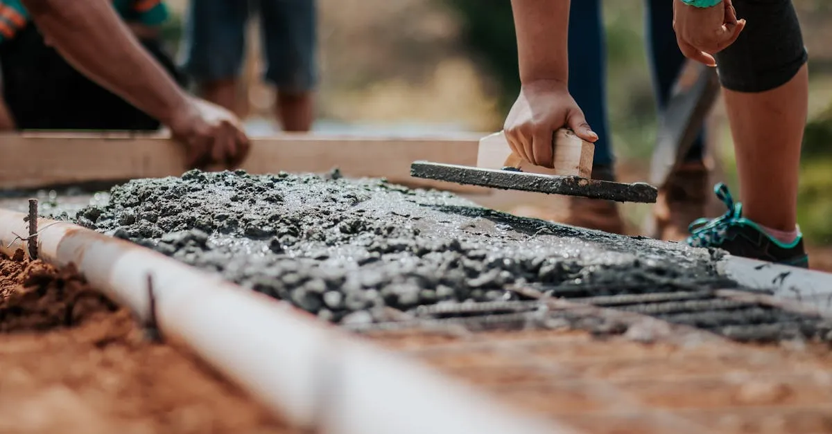
“Any job with curves or special elevation measurements benefits immensely. For example, the garden fence with concrete curved paths – it would have been nearly impossible without Moasure. Using ArcSite alongside Moasure ensures perfect post spacing and accurate planning, even when the ground is unforgiving.”
Built for Real-World Challenges
Traditional measuring tools often fall short when dealing with irregular terrains or complex layouts. Moasure addresses these challenges by utilizing motion sensors to capture data in 3D space, meaning that users can benefit from being able to:
- Measure and Draw Simultaneously: Generate accurate, dimensioned drawings as you move. Trace along edges with Moasure to instantly capture complex shapes and add multiple layers within a single measurement.
- Generate Instant Calculations: Automatically calculate perimeters, areas, elevation changes, grades, and volumes. From curved lawns to drainage planning, Moasure delivers the numbers you need without extra steps.
- Instantly Map Sites in 3D: Capture terrain in three dimensions – produce contour lines, true surface area, and cut & fill volumes. Even tricky earthwork projects become more efficient and profitable.
Michael notes:
“For precision, Moasure is unmatched. Earlier this year, I quoted a split-rail fence and welded wire mesh for a garden. When I arrived, it had weird curved concrete plots that were hard to measure manually. Moasure let me measure the plots, consider utility lines, and bring everything into ArcSite for precise planning. I could layer different measurements, adjust for gas lines, and make the project achievable faster and more accurately.”
“I can note utilities on the fly in the Moasure app – gas, irrigation, electric – and it carries over to ArcSite. The recent 3.2 app update lets me use voice notes too, which makes things even faster.”
This capability ensures that every measurement is accurate, reducing the risk of errors and rework.
Real-World Impact: More Time, Less Paperwork
By adopting Moasure and ArcSite, professionals can:
- Save Time: Eliminate manual measurements and reduce the time spent on-site.
- Increase Accuracy: Ensure that every measurement is accurate, leading to more accurate proposals and reduced errors.
- Enhance Professionalism: Present clients with detailed, professional proposals that instill confidence.
Michael adds:
“ArcSite has always helped us present clear proposals. Adding Moasure makes the process faster and more accurate, which clients definitely notice.”
One Workflow, Many Benefits
The combined power of Moasure and ArcSite offers a comprehensive solution:
- Capture Measurements: Use Moasure to gather accurate data on-site.
- Create Drawings: Import this data into ArcSite to generate detailed, scalable drawings.
- Generate Proposals: Utilize ArcSite's tools to create professional proposals, complete with material takeoffs and cost estimates.
- Close Deals: Present clients with accurate, professional proposals that facilitate quicker decision-making.
This integrated workflow not only enhances efficiency, but also improves the overall client experience.
Looking Ahead: Continuous Innovation
Both Moasure and ArcSite are committed to continuous improvement. Regular updates to Moasure's app introduce new features that enhance its integration with ArcSite, while ArcSite develops AI-powered tools and enhanced libraries to provide even greater value to users. This ongoing innovation ensures that professionals always have access to the latest tools and technologies, keeping them ahead of the competition.
When you pair Moasure with ArcSite, you unlock a faster, more reliable workflow from the very first measurement. No missed details, no project delays, just a smooth transition from site takeoff to signed proposal. Ready to streamline your process and close more jobs on the spot? Discover how Moasure and ArcSite seamlessly integrate.
Guest blog written by Moasure’s Kelly Salmon.
Categories
INDUSTRY