Site Survey Software
Data Collection and Site Survey Software
Instantly capture precise site measurements and project requirements, seamlessly integrate them with your inspection process, and streamline your documentation deliverables with ease.

Key Site Survey Software Features
The best site survey software empowers contractors and field teams to capture data accurately and efficiently—right where the work happens. ArcSite combines mobile-friendly design with precision tools to streamline every part of the surveying process. With offline functionality, inspectors can draw, measure, and record notes even without an internet connection, ensuring nothing slows down fieldwork.
Streamlined Field Drawing for Efficient Surveys
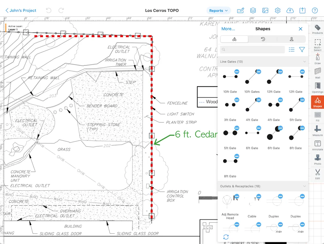
ArcSite simplifies site survey software with intuitive tools, enabling you to create clear, precise diagrams directly in the field effortlessly.
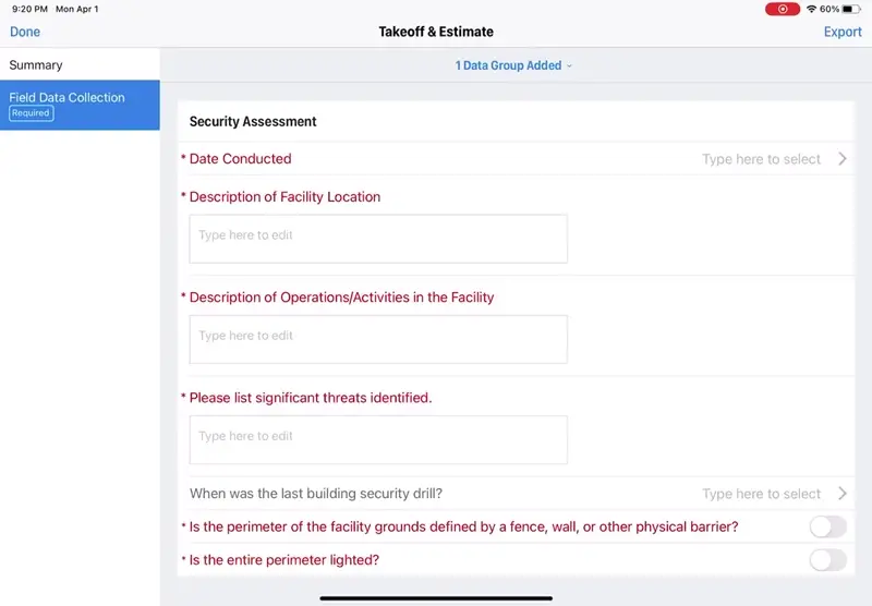
Customizable Forms & Smart Data Collection
Capture precise site details with ArcSite's customizable forms and data fields. Adapt surveys to your workflow, record critical measurements, notes, and photos—all in one seamless process.
Satellite Imaging for Precise Representation
ArcSite lets you overlay site drawings and survey notes directly onto satellite maps—perfect for large or complex job sites. Quickly orient yourself in the field, confirm property lines, and mark key features or problem areas with GPS-level precision. Using real-world map context makes your surveys easier to interpret and ensures crews and clients see exactly where work is needed.
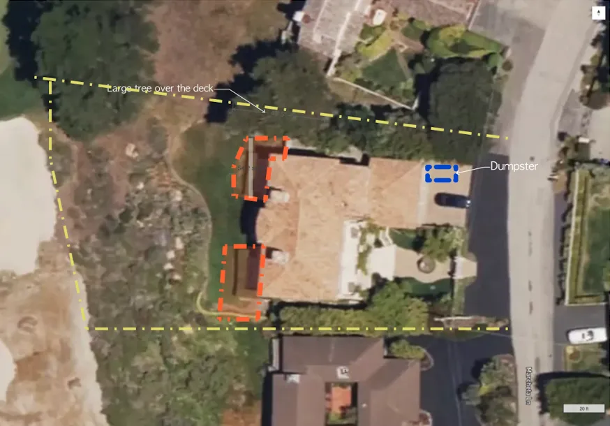
Photo and Field Annotation
Capture exactly what you see on-site with ArcSite’s photo and field annotation tools. Snap images during your site survey, add notes, arrows, or highlights to call out specific issues, and link them directly to your drawings. It’s a clear, efficient way to document site conditions, flag concerns, and keep your entire team aligned—no guesswork, no backtracking.

Secure Cloud Collaboration
Empower your team with seamless communication and data sharing through our secure cloud platform, tailored specifically for site survey professionals.
.webp)
Get an industry-focused demo of ArcSite to see all the benefits your team can use to work more efficiently.
Get a DemoOur users rave about the benefits they experience with ArcSite.
Listen to stories from professionals like you who used ArcSite to save them time, reduce costs, and alleviate daily work frustrations.

“The very first day that I was using ArcSite in the field, I was able to close a $42,000 job in about 45 minutes. That process before would take anywhere from two to three hours minimum.”
Nick Birchoff
Lead Estimator - Nevada Fence

45-Minute $42,000 Deal Closure with Efficient ArcSite Sketching
Estimation Time Reduced from Hours to Minutes, Enhancing Productivity
On-Site Estimates with ArcSite Increased Close Rates by Over 70%
Unique Competitive Edge in Market Due to ArcSite's Powerful Features

“I am so accurate with all my drawings and measurements. Now, our engineers have all the information they need and can answer questions on the spot.”
Collin Dozier
Field Inspector - JES Foundation Repair

Over $2 Million in Sales with ArcSite's Precision Drawing Tools
Streamlined Site Visits: Digital Plans on First Visit, Eliminating Redraws
Enhanced Field Accuracy: Real-Time Photo Sharing and Crawlspace Navigation with ArcSite
Increased Customer Engagement: Detailed, Professional Presentations Using ArcSite

“I can confidently say that ArcSite has revolutionized our workflow. The clarity and precision it brings to project planning and execution are unparalleled; it directly contributes to our clients' satisfaction and our business success.”
Rick Randall
Owner - Pinehurst Turf Pros

Revolutionized Project Approach: Time-Saving Precision with ArcSite and Moasure
Error-Free Measurements: Elevated Field Accuracy Boosts Service Excellence
Streamlined Administration: Single, Digitally Signable Contract PDFs Enhance Client Experience
Client Engagement and Satisfaction Soared: Clear, Comprehensive Project Illustrations with ArcSite
“I went to the site Monday without ArcSite, spent all afternoon printing then marking up on A4 paper. Once I returned, I had to then scan it, convert it to PDF, upload it to Autodesk Design Review, then mark up all the circuits using the correct symbols onto the system. All this could have been done at the source [using ArcSite]. Instead, it was done at the office, wasting many hours of time.”
Paul Gibson
Surveyor - Johnson Controls

Halved Field Time: ArcSite's Efficient Drawing and Data Collection
Accurate Data in Single Visits: Eliminated Rework with ArcSite’s Digital Tools
Enhanced Team Collaboration: Instant Data and Photo Sharing with ArcSite
Custom Solutions for Complex Systems: ArcSite’s Custom Shapes and Photo Integration

Trusted by the Pros. Honored for Innovation.